


| 
|
This page describes how the rotating Mars movie was made.
To create the spinning Mars globe, first I took pictures of the different sides of Mars. Doing so was complicated by several things. As viewed from where I live in the Northern Hemisphere, Mars never got higher than about 34° above the horizon. Low-atmospheric turbulence made it difficult to get sharp images. Adding to the challenge, 2003 was an unusually rainy year where I live on the East Coast of the US. As a result, all of my images of Mars were taken during average to poor seeing. Some were even taken through holes in the clouds.
To minimize the effects of the turbulence, I tried to take images when Mars was as high in the sky as possible. This meant that I couldn't just wait for Mars to rotate through the night to see its different sides, but had to wait for its rotation rate to slowly change the side facing me. Mars takes a little more than a day to complete one rotation. If viewed at the same time each night, it appears to rotate backwards a bit each night, so it takes about a month to see all of its sides. During the month of imaging surrounding Mars' closest approach, I managed to capture ten images.
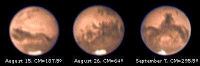
Shown above are three of the ten images used to create the movie. Each image is a composite of about 400 video frames selected from 1,800 taken each session using a Philips ToUcam Pro through an Astro-Physics 155mm (6.1 inch) refractor at about f50. Exposure ranged from 1/30 second on hazy nights to 1/100 second on clear nights, all at ten frames/second. The video was captured using K3CCDTools, combined using Registax, and further processed in Photoshop.
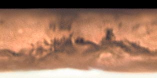
Once I had images of all sides of Mars, I used Iris software to create a composite cylindrical projection map, shown above, and then re-projected that map onto a sphere at different central meridian positions to create the frames of the movie. The frames were further optimized in Photoshop and assembled in ImageReady. (A larger view of the map with surface features and spacecraft landing sites marked is shown here.)
The region above about 71° north on the map appears black because Mars' North Pole was tilted away from Earth during this apparition and wasn't visible. Since I reconstructed the animated globe using the same tilt, the missing region didn't appear in the final movie.
An additional complication came from the fact that Mars' southern polar cap shrank noticeably during the four weeks of imaging. This is apparent in the set of three images shown above, which span 23 days, and in the next image.
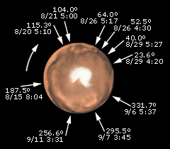
Above is a view of Mars' South Pole, projected from the collected images, with Mars' central meridian position and the Universal Time dates of the ten images marked. The apparent notch around 225° is a result of joining images taken on August 15 and September 11. It shows how much the southern polar cap shrank in that region during that time.
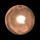
To correct for the shrinking cap, I created an average southern view, shown above, and used it to generate the southern polar region of the map used to generate the movie. The resulting movie consists of 240 frames, each differing by 1.5° in central meridian, running at 20 frames/second. These 240 frames, which take 12 seconds to loop, are the result of more than 18,000 raw video frames taken over a period of four weeks!
The movie is displayed on this site in several versions:
- A version consisting of 240 frames at twenty frames/second.
- An anaglyphic (red/blue glasses) 3D view.
- A stereo (left/right images) 3D view.
(Please note that all images shown here are copyrighted ©2003-2004 and must not be copied on your web site without my written permission!) Here's how to contact me.
| |||||||||||||||||
|
Astrophotography Books – Astronomy Books |